

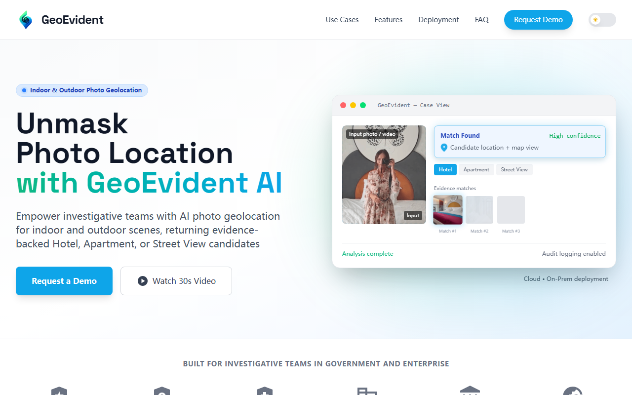
First Impressions: A Purpose-Built Investigation Tool
Upon visiting the GeoEvident website, I immediately noticed the deliberate, no-nonsense design. There is no chatbot or free trial here — instead, the homepage presents a clear workflow: upload a photo, receive ranked location candidates (Hotel, Apartment, Street View), and export a case-ready report. The platform is built for “government and enterprise” teams, and the landing page reinforces that with sections on audit logging, role-based access control, and on-premise deployment. After watching the 30-second video demo, I observed a case view where an input photo of a hotel interior is matched against a database, returning three candidates with descending confidence scores (97.2%, 95.0%, 92.8%) and visual evidence side-by-side. This is not a consumer app — it is a forensic tool for analysts who need verifiable outputs.
What GeoEvident Solves and How It Works
GeoEvident addresses a specific pain point: determining where a photo was taken when metadata (EXIF/GPS) is stripped, unavailable, or unreliable. Unlike generic reverse image search tools, GeoEvident focuses on visual cues that are often overlooked — the pattern of a hotel lobby’s ceiling tiles, the shape of a window frame in an apartment, or the arrangement of street signs in an outdoor shot. The platform then surfaces likely locations from its curated dataset of hotels, apartments, and street views, providing evidence matches that analysts can inspect, compare, and document. The technical stack appears to use proprietary computer vision and machine learning models, though the site does not disclose specific frameworks. Deployment options include a managed Secure Cloud or an On-Premise air-gapped installation via Docker/Kubernetes — a clear nod to sensitive investigations where data cannot leave a restricted environment.
Strengths and Limitations
The most impressive strength is the evidence-backed workflow. GeoEvident does not just return a map pin — it shows visual similarities (e.g., matching furniture, lighting, or signage) so the analyst can justify the conclusion. The case report export and audit logging are essential for legal defensibility. I also appreciate the flexible deployment: cloud for convenience, on-prem for compliance. However, limitations are real. Accuracy is directly tied to “the presence of distinctive visual cues” — a generic white wall with no distinguishable features will yield low confidence or no match. The tool also cannot perform real-time tracking; it is strictly forensic. Pricing is not publicly listed; interested buyers must request a demo, which can be a barrier for small teams or casual evaluators. For context, competitors like PicTriev and Image Search by TinEye offer broader but less specialized reverse image searches, while Verisk’s fraud detection tools overlap with the insurance use case but lack GeoEvident’s integrated evidence export.
Who Should Use GeoEvident?
GeoEvident is best suited for investigative teams in law enforcement, border control, insurance SIU, and OSINT journalism — anyone who needs to tie a photo to a specific hotel, apartment, or street location with supporting evidence for reports or litigation. It is also ideal for AML compliance teams verifying location claims in due diligence. Conversely, if you only need quick, casual geolocation (like identifying a restaurant from a social media photo), free tools like Google Images or Yandex Pictures will suffice at no cost. This tool is overkill for hobbyists. The requirement for a vetted demo also means smaller organizations may face friction getting started. Still, for mission-critical investigations where accuracy and auditability trump convenience, GeoEvident fills a clear gap in the market.
My recommendation: if you are a government or enterprise investigator handling sensitive imagery, request a demo to test GeoEvident against your real-world scenarios. The evidence trail and deployment flexibility justify the investment. For others, wait until a self-serve tier or public pricing emerges.
Visit GeoEvident at https://geoevident.com to explore it yourself.


Comments